
Dosya:West Bank & Gaza Map 2007 (Settlements).png

Bu dosya Wikimedia Commons'ta bulunmaktadır. Dosyanın açıklaması aşağıda gösterilmiştir. Commons, serbest/özgür telifli medya dosyalarının bulundurulduğu depodur. Siz de yardım edebilirsiniz. |
.png)
Özet
This map is a modification, suggested as a replacement for, or in addition to, the one uploaded by ChrisO at
http://en.wikipedia.org/wiki/Image:Israel_and_occupied_territories_map.png
which is used in the Wikipedia article "Palestine," under the History subheading Current Status.
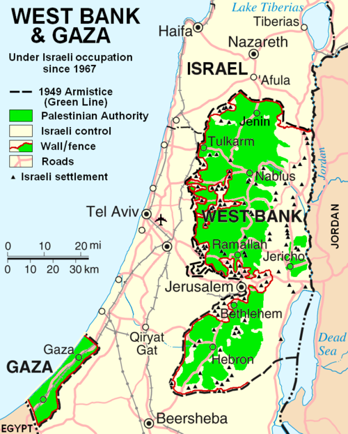
My modification shows "facts on the ground" which are essential to any understanding of the situation in Palestine today. The geographic facts are not in dispute. They have been widely published in print and on the internet.
Both my map and the ChrisO map are modifications of a 2004 United Nations map of Israel:
http://www.un.org/Depts/Cartographic/map/profile/israel.pdf
(public domain) in which the three Occupied Territories, the West Bank, Gaza, and Golon, are given the same brown color as Israel's neighboring countries: Egypt, Jordan, Syria, and Lebanon. ChrisO colors the West Bank, Gaza, and Golon light green and renames the map "Israel and the Occupied Territories." However Golon is Syrian, not Palestinian. For an article on Palestine, attention should be on the West Bank and Gaza.
My modification crops out Golon and the Negev desert to focus in on the West Bank and Gaza. It also incorporates information from several published sources to show the land and resources actually available to Palestinian people in these two territories, the West Bank in particular.
The main source of information on barriers and land distribution comes from a map by the United Nations Office for the Coordination of Humanitarian Affairs:
http://www.ochaopt.org/documents/OCHAoPt_ClsrMp_WB0106_En.pdf archive copy at the
Wayback Machine supplemented by two more United Nations maps:
http://www.ochaopt.org/documents/WB_Barrier_Projections_July06.pdf archive copy at the
http://www.ochaopt.org/documents/WB_Closure_Access_revised_CAP_June06.pdf archive copy at the
Two Israeli organizations have published similar maps:
    http://www.btselem.org/Download/Separation_Barrier_Map_Eng.pdf
    http://www.icahd.org/eng/images/articles/the-matrix-of-control.gif archive copy at the
And finally, the Washington Post published all this information on a full-page newspaper map here.
Each of these maps is much too detailed to illustrate a Wikipedia article. My modification simplifies the information for use on a map similar in scale to the other maps in the article on Palestine.
A similar map without the Israeli settlements is posted here
The word Palestine has been removed from the title of this map to satisfy criticism that the former title implied a Palestinian sovereignty over the West Bank and Gaza.
Lisanslama
| Ben, bu işin telif sahibi, bu işi kamu malı olarak yayınlıyorum. Bu dünya çapında geçerlidir. Bazı ülkelerde bu yasal olarak mümkün olmayabilir; öyleyse: Ben, bu işi herhangi bir amaç için, herhangi bir şart olmaksızın, yasalarca gerekli olmadıkça, herkesin kullanmasına izin veriyorum. |
derivative works
Bu dosyanın türev çalışmaları: Wbgz.svg
Dosya geçmişi
Dosyanın herhangi bir zamandaki hâli için ilgili tarih/saat kısmına tıklayın.
| Tarih/Saat | Küçük resim | Boyutlar | Kullanıcı | Yorum | |
|---|---|---|---|---|---|
| güncel | 22.55, 29 Ekim 2013 | | 780 × 970 (86 KB) | Hex | Correct capitalization in legend. |
| 22.54, 29 Ekim 2013 |  | 780 × 970 (86 KB) | Hex | Correct capitalization in legend. | |
| 06.21, 12 Ocak 2009 |  | 780 × 970 (105 KB) | HowardMorland | Replace .gif file with identical .png file <!--{{ImageUpload|basic}}--> |
Dosya kullanımı
Bu görüntü dosyasına bağlantısı olan sayfalar:
Küresel dosya kullanımı
Aşağıdaki diğer vikiler bu dosyayı kullanmaktadır:
- am.wikipedia.org üzerinde kullanımı
- ar.wikipedia.org üzerinde kullanımı
- ast.wikipedia.org üzerinde kullanımı
- azb.wikipedia.org üzerinde kullanımı
- bg.wikipedia.org üzerinde kullanımı
- ca.wikipedia.org üzerinde kullanımı
- ckb.wikipedia.org üzerinde kullanımı
- cy.wikipedia.org üzerinde kullanımı
- da.wikipedia.org üzerinde kullanımı
- de.wikipedia.org üzerinde kullanımı
- de.wikinews.org üzerinde kullanımı
- de.wikivoyage.org üzerinde kullanımı
- en.wikipedia.org üzerinde kullanımı
- Israeli settlement
- List of cities in Palestine
- Talk:List of ongoing armed conflicts
- User:Timeshifter/Userboxes
- User:Gimmetrow/test
- User:Gimmetrow/test2
- Talk:Jerusalem/Archive 15
- Talk:Palestinian Authority/Archive 2
- File talk:West Bank & Gaza Map 2007 (Settlements).png
- Wikipedia:Top 25 Report/July 13 to 19, 2014
- Wikipedia:Top 25 Report/July 20 to 26, 2014
- Wikipedia:Top 25 Report/July 27 to August 2, 2014
- Talk:Palestine/Archive 12
- User:Timeshifter/Userboxes/Palestine: Peace Not Apartheid. By Jimmy Carter
- User:TheSouthernIrishman
- User:Dare2Leap/info
- User:Timeshifter/Archive 2
- Wikipedia talk:WikiProject Israel Palestine Collaboration/Archive 9
- User:Falcaorib/Israel and Palestine
- en.wikinews.org üzerinde kullanımı
- eo.wikipedia.org üzerinde kullanımı
- es.wikipedia.org üzerinde kullanımı
- eu.wikipedia.org üzerinde kullanımı
- fa.wikipedia.org üzerinde kullanımı
.png)
Bu dosyanın daha fazla küresel kullanımını görüntüle.
.png)
.png)