Dosya:Weimar Republic states map.svg - Vikipedi
İçeriğe atla
Ana menü
Gezinti
  • Anasayfa
  • Hakkımızda
  • İçindekiler
  • Rastgele madde
  • Seçkin içerik
  • Yakınımdakiler
Katılım
  • Deneme tahtası
  • Köy çeşmesi
  • Son değişiklikler
  • Dosya yükle
  • Topluluk portalı
  • Wikimedia dükkânı
  • Yardım
  • Özel sayfalar
Vikipedi Özgür Ansiklopedi
Ara
  • Bağış yapın
  • Hesap oluştur
  • Oturum aç
  • Bağış yapın
  • Hesap oluştur
  • Oturum aç

Dosya:Weimar Republic states map.svg

Sayfa içeriği diğer dillerde desteklenmemektedir.
  • Dosya
  • Tartışma
  • Oku
  • Wikimedia Commons üzerinde gör
  • Yerel açıklama ekle
  • Yerel açıklama kaynağı ekle
Araçlar
Eylemler
  • Oku
  • Wikimedia Commons üzerinde gör
  • Yerel açıklama ekle
  • Yerel açıklama kaynağı ekle
Genel
  • Sayfaya bağlantılar
  • Basılmaya uygun görünüm
  • Sayfa bilgisi
  • Kısaltılmış URL'yi al
  • Karekodu indir
Diğer projelerde
Görünüm
Vikipedi, özgür ansiklopedi
  • Dosya
  • Dosya geçmişi
  • Dosya kullanımı
  • Küresel dosya kullanımı
  • Üstveri
Dosya:Weimar Republic states map.svg
Bu SVG dosyasının PNG önizlemesinin boyutu: 715 × 599 piksel. Diğer çözünürlükler: 286 × 240 piksel | 573 × 480 piksel | 916 × 768 piksel | 1.222 × 1.024 piksel | 2.444 × 2.048 piksel | 976 × 818 piksel.
Tam çözünürlük (SVG dosyası, sözde 976 × 818 piksel, dosya boyutu: 949 KB)
Bu dosya Wikimedia Commons'ta bulunmaktadır. Dosyanın açıklaması aşağıda gösterilmiştir.
Commons, serbest/özgür telifli medya dosyalarının bulundurulduğu depodur. Siz de yardım edebilirsiniz.
Bu dosya Wikimedia Commons'ta bulunmaktadır.

Özet

AçıklamaWeimar Republic states map.svg
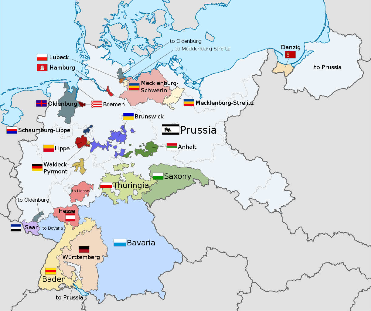
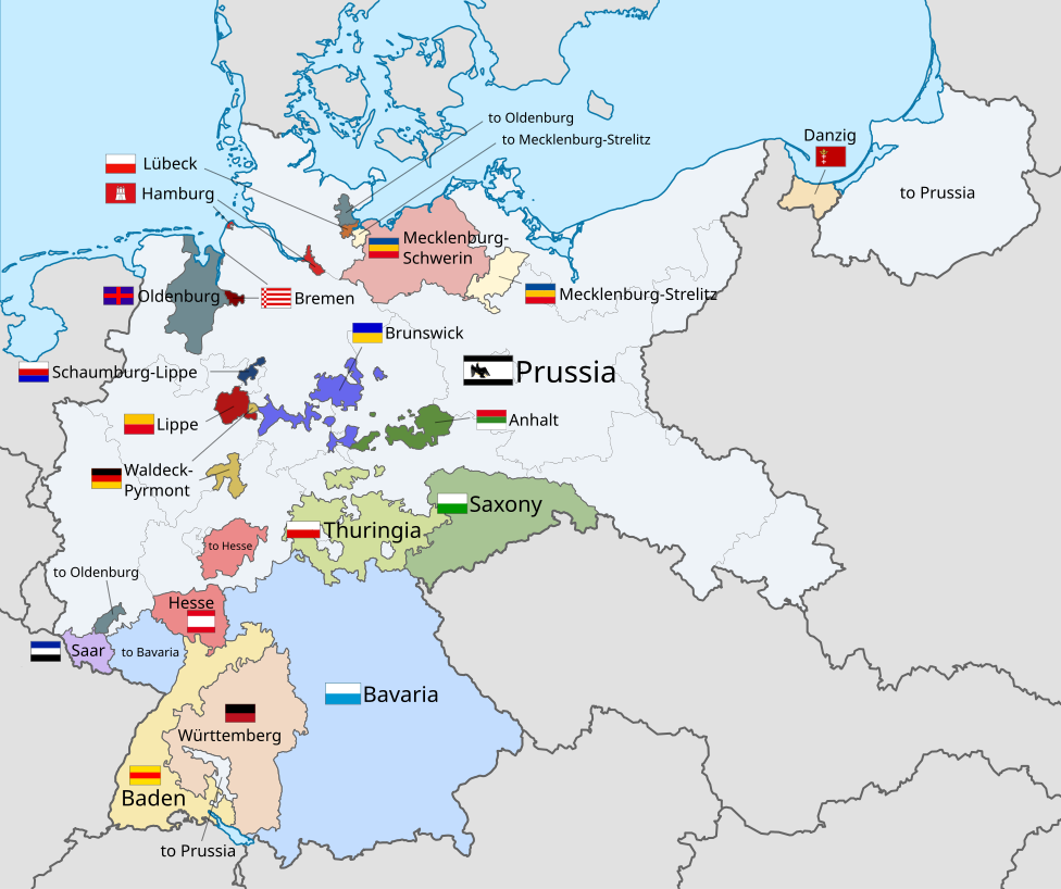
English: A map of the states of the Weimar Republic, showing their location, flags and names in English.
Tarih 5 Kasım 2015
Kaynak Bu dosya şu kaynaktan türetilmiştir: Weimar Republic blank map.svg: 
 
This vector image includes elements that have been taken or adapted from this file:
 Flag of Prussia (1918–1933).svg (by TRAJAN 117).
 
This vector image includes elements that have been taken or adapted from this file:
 Flag of the Free City of Danzig.svg (by Fornax).
 
This vector image includes elements that have been taken or adapted from this file:
 Flagge Herzogtum Anhalt.svg (by David Liuzzo).
 
This vector image includes elements that have been taken or adapted from this file:
 Flagge Großherzogtum Baden (1891–1918).svg (by David Liuzzo).
 
This vector image includes elements that have been taken or adapted from this file:
 Flag of Bavaria (striped).svg (by Boris23).
 
This vector image includes elements that have been taken or adapted from this file:
 Flag of Bremen.svg (by Madden).
 
This vector image includes elements that have been taken or adapted from this file:
 Flagge Herzogtum Braunschweig.svg (by David Liuzzo).
 
This vector image includes elements that have been taken or adapted from this file:
 Flagge Großherzogtum Hessen ohne Wappen.svg (by David Liuzzo).
 
This vector image includes elements that have been taken or adapted from this file:
 Flagge Fürstentum Lippe.svg (by David Liuzzo).
 
This vector image includes elements that have been taken or adapted from this file:
 Flagge Fürstentum Schaumburg-Lippe.svg (by David Liuzzo).
 
This vector image includes elements that have been taken or adapted from this file:
 Flag of Hamburg.svg (by Greentubing~commonswiki).
 
This vector image includes elements that have been taken or adapted from this file:
 Flagge Großherzogtümer Mecklenburg.svg (by David Liuzzo).
 
This vector image includes elements that have been taken or adapted from this file:
 Flag of the Free City of Lübeck.svg (by Slarre~commonswiki).
 
This vector image includes elements that have been taken or adapted from this file:
 Civil flag of Oldenburg.svg (by Lokal Profil).
 
This vector image includes elements that have been taken or adapted from this file:
 Flagge Königreich Sachsen (1815-1918).svg (by David Liuzzo).
 
This vector image includes elements that have been taken or adapted from this file:
 Flagge Königreich Württemberg.svg (by David Liuzzo).
Yazar
  • File:Weimar Republic blank map.svg: Shadowxfox / türetilmiş iş Alphathon /'æɫfə.θɒn/ 
Diğer sürümler
  • English: Weimar Republic (German version) Deutsch: Weimarer Republik (deutsche Version)
    English: Weimar Republic (German version)
    Deutsch: Weimarer Republik (deutsche Version)
  • English: Weimar Republic (Esperanto version) Deutsch: Weimarer Republik (Esperanto-Version)
    English: Weimar Republic (Esperanto version)
    Deutsch: Weimarer Republik (Esperanto-Version)
  • English: Weimar Republic (Macedonian version) Deutsch: Weimarer Republik (mazedonische Version)
    English: Weimar Republic (Macedonian version)
    Deutsch: Weimarer Republik (mazedonische Version)
  • English: Weimar Republic (Russian version) Deutsch: Weimarer Republik (russische Version)
    English: Weimar Republic (Russian version)
    Deutsch: Weimarer Republik (russische Version)
  • English: Weimar Republic (Spanish version) Deutsch: Weimarer Republik (spanische Version)
    English: Weimar Republic (Spanish version)
    Deutsch: Weimarer Republik (spanische Version)
  • English: German Empire (English version) Deutsch: Deutsches Kaiserreich (englische Version)
    English: German Empire (English version)
    Deutsch: Deutsches Kaiserreich (englische Version)
  • English: German Empire (Scottish Gaelic version) Deutsch: Deutsches Kaiserreich (schottisch-gälische Version)
    English: German Empire (Scottish Gaelic version)
    Deutsch: Deutsches Kaiserreich (schottisch-gälische Version)
SVG gelişimi
InfoField
 Bu SVG kaynak kodu geçerlidir.
 Bu vektörel grafik Inkscape ile oluşturuldu.
  Bu SVG dosyası, gömülü metin editörü kullanarak kolayca çevirebilir.

Lisanslama

Ben, bu işin telif sahibi, burada işi aşağıdaki lisans altında yayımlıyorum:
w:tr:Creative Commons
atıf benzer paylaşım
Bu dosya, Creative Commons Atıf-Benzer Paylaşım 3.0 Taşınmamış lisansı ile lisanslanmıştır
Şu seçeneklerde özgürsünüz:
  • paylaşım – eser paylaşımı, dağıtımı ve iletimi
  • içeriği değiştirip uyarlama – eser adaptasyonu
Aşağıdaki koşullar geçerli olacaktır:
  • atıf – Esere yazar veya lisans sahibi tarafından belirtilen (ancak sizi ya da eseri kullanımınızı desteklediklerini ileri sürmeyecek bir) şekilde atıfta bulunmalısınız.
  • benzer paylaşım – Maddeyi yeniden düzenler, dönüştürür veya inşa ederseniz, katkılarınızı özgünüyle aynı veya uyumlu lisans altında dağıtmanız gerekir.
https://creativecommons.org/licenses/by-sa/3.0CC BY-SA 3.0 Creative Commons Attribution-Share Alike 3.0 truetrue

Code for clickable map

en:Free State of Waldeck-Pyrmonten:Free State of Waldeck-Pyrmonten:Free State of Waldeck-Pyrmonten:Free State of Schaumburg-Lippeen:Free State of Schaumburg-Lippeen:Free State of Lippeen:Free State of Lippeen:Free City of Lübecken:Free City of Lübecken:Hamburgen:Hamburgen:Hamburgen:Hamburgen:Hamburgen:Free State of Mecklenburg-Strelitzen:Free State of Mecklenburg-Strelitzen:Free State of Mecklenburg-Strelitzen:Free State of Mecklenburg-Strelitzen:Free State of Mecklenburg-Schwerinen:Bremen (state)en:Bremen (state)en:Bremen (state)en:Free State of Brunswicken:Free State of Brunswicken:Free State of Brunswicken:Free State of Brunswicken:Free State of Brunswicken:Free State of Anhalten:Free State of Anhalten:Free State of Anhalten:Free State of Oldenburgen:Free State of Oldenburgen:Free State of Oldenburgen:Free State of Oldenburgen:Free State of Oldenburgen:Free State of Saxonyen:Free State of Prussiaen:Free State of Prussiaen:Free State of Prussiaen:Free State of Thuringiaen:Free State of Thuringiaen:Free State of Thuringiaen:Republic of Badenen:People's State of Hesseen:People's State of Hesseen:Free People's State of Württembergen:Free State of Bavariaen:Free State of Bavariaen:Saar (League of Nations)en:Saar (League of Nations)en:Free State of Prussiaen:Free State of Prussiaen:Free State of Prussiaen:Free State of Prussiaen:Free State of Prussiaen:Free State of Prussiaen:Free State of Prussiaen:Free State of Prussiaen:Free State of Prussiaen:Free State of Prussiaen:Free State of Prussiaen:Free State of Prussiaen:Free State of Prussiaen:Free State of Prussiaen:Free State of Prussiaen:Free State of Prussiaen:Free State of Prussiaen:Free State of Prussiaen:Free State of Prussiaen:Free State of Prussiaen:Free State of Prussiaen:Free State of Prussiaen:Free State of Prussiaen:Free State of Prussiaen:Free State of Prussiaen:Free State of Prussiaen:Free State of Prussiaen:Free State of Prussiaen:Free City of Danzigen:Free City of Danzigen:Free City of Danzig

Altyazılar

Bu dosyanın temsil ettiği şeyin tek satırlık açıklamasını ekleyin.
A map of the states of the Weimar Republic, showing their location, flags and names

Bu dosyada gösterilen öğeler

betimlenen

Weimar Cumhuriyeti döneminde kurulan Alman devletleri

telif hakkı durumu

telif hakkı alınmış

telif hakkı lisansı

Creative Commons Atıf-AynıLisanslaPaylaş 3.0 Yerelleştirilmemiş

kuruluşu

5 Kasım 2015

ortam türü

image/svg+xml

dosya boyutu

972.057 bayt

boyu

818 piksel

genişliği

976 piksel

sağlama toplamı

a8d3b37e093da00b11236c02d692cb517f57690d

tespit yöntemi: SHA-1

Dosya geçmişi

Dosyanın herhangi bir zamandaki hâli için ilgili tarih/saat kısmına tıklayın.

Tarih/SaatKüçük resimBoyutlarKullanıcıYorum
güncel22.22, 17 Aralık 202122.22, 17 Aralık 2021 tarihindeki sürümün küçültülmüş hâli976 × 818 (949 KB)AlphathonCorrections to Anhalt and Brunswick
03.28, 5 Kasım 201503.28, 5 Kasım 2015 tarihindeki sürümün küçültülmüş hâli976 × 818 (981 KB)Alphathon{{Information |Description={{en|A map of the states of the en:Weimar Republic, showing their location, flags and names in English.}}{{Valid SVG}} |Source={{Derived from|File:Weimar Republic blank map.svg|display=50}} {{AttribSVG|Flag of Prussia (...

Dosya kullanımı

Bu görüntü dosyasına bağlantısı olan sayfalar:

  • Bağımsız Schaumburg-Lippe Devleti
  • Weimar Cumhuriyeti döneminde kurulan Alman devletleri

Küresel dosya kullanımı

Aşağıdaki diğer vikiler bu dosyayı kullanmaktadır:

  • ar.wikipedia.org üzerinde kullanımı
    • ألمانيا النازية
    • جلايش شالتونج
    • رايخسشتاتهالتر
  • ast.wikipedia.org üzerinde kullanımı
    • Organización territorial de la República de Weimar
  • ca.wikipedia.org üzerinde kullanımı
    • Estats de la República de Weimar
    • Reichsstatthalter
  • cs.wikipedia.org üzerinde kullanımı
    • Gleichschaltung
  • en.wikipedia.org üzerinde kullanımı
    • Gleichschaltung
    • Weimar Republic
    • States of Germany
    • Prussia
    • Reichsrat (Germany)
    • Reichsstatthalter
    • States of the Weimar Republic
    • Template:Weimar Republic States
    • Provisional Law and Second Law on the Coordination of the States with the Reich
    • Nazi Party election results
    • Law on the Reconstruction of the Reich
    • User:Falcaorib/Germany and Prussia
  • fa.wikipedia.org üzerinde kullanımı
    • جمهوری وایمار
    • الگو:ایالت‌های جمهوری وایمار
  • fy.wikipedia.org üzerinde kullanımı
    • Gleichschaltung
  • gd.wikipedia.org üzerinde kullanımı
    • Poblachd Weimar
  • got.wikipedia.org üzerinde kullanımı
    • 𐍂𐌰𐌹𐍃𐍀𐌿𐌱𐌻𐌹𐌺𐌰 𐍅𐌰𐌾𐌼𐌰𐍂𐌹𐍃
  • hy.wikipedia.org üzerinde kullanımı
    • Մասնակից:Anna Watson Holmes/Ավազարկղ
  • id.wikipedia.org üzerinde kullanımı
    • Jerman Nazi
    • Negara bagian Republik Weimar
    • Templat:Weimar Republic States
  • it.wikipedia.org üzerinde kullanımı
    • Gleichschaltung
  • kk.wikipedia.org üzerinde kullanımı
    • Нацистік Германия
  • lt.wikipedia.org üzerinde kullanımı
    • Nacistinė Vokietija
  • ms.wikipedia.org üzerinde kullanımı
    • Negeri-negeri Republik Weimar
  • pt.wikipedia.org üzerinde kullanımı
    • Prússia
    • República de Weimar
    • Gleichschaltung
    • Reichsstatthalter
    • Reichsrat
    • Lei sobre a Reconstrução do Reich
  • simple.wikipedia.org üzerinde kullanımı
    • Template:Weimar Republic States
    • States of the Weimar Republic
  • ur.wikipedia.org üzerinde kullanımı
    • جمہوریہ وایمار
    • سانچہ:Weimar Republic States
  • zh.wikipedia.org üzerinde kullanımı
    • 魏瑪共和國
    • 一体化 (纳粹术语)
    • Template:威瑪共和國邦國

Üstveri

Bu dosyada, muhtemelen fotoğraf makinesi ya da tarayıcı tarafından eklenmiş ek bilgiler mevcuttur. Eğer dosyada sonradan değişiklik yapıldıysa, bazı bilgiler yeni değişikliğe göre eski kalmış olabilir.

Genişlik975.66052
Yükseklik817.62897
"https://tr.wikipedia.org/wiki/Dosya:Weimar_Republic_states_map.svg" sayfasından alınmıştır
  • Gizlilik politikası
  • Vikipedi hakkında
  • Sorumluluk reddi
  • Davranış Kuralları
  • Geliştiriciler
  • İstatistikler
  • Çerez politikası
  • Mobil görünüm
  • Wikimedia Foundation
  • Powered by MediaWiki
Dosya:Weimar Republic states map.svg
Konu ekle