
Dosya:Pyrenees topographic map-fr.svg

Bu dosya Wikimedia Commons'ta bulunmaktadır. Dosyanın açıklaması aşağıda gösterilmiştir. Commons, serbest/özgür telifli medya dosyalarının bulundurulduğu depodur. Siz de yardım edebilirsiniz. |
![]()
Detailed map of large dimension. For a better viewing, click on the link of the image above.
Carte détaillée de grande dimension. Pour une visualisation optimale, cliquer sur le lien de l'image ci-dessus.
Özet
| Tarif |
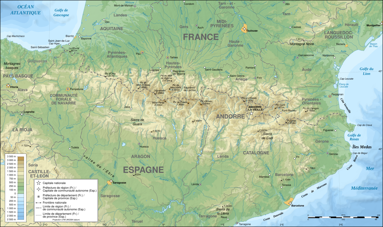
English: Topographic map in French of the Pyrenees mountains.
Note: The shaded relief is a raster image embedded in the SVG file. Français : Carte topographique des Pyrénées en francais.
Note : Le relief ombré est une image bitmap embarquée dans le fichier SVG. Português: Mapa topográfico (em Francês) dos Pirenéus.
Español: Mapa topográfico (en francés) de los Pirineos.
UTM projection; WGS84 datum; shaded relief (composite image of N-W, W and N lightning positions);
|
||
| SVG gelişimi | |||
| Tarih | May 2007 (modified September 2008) | ||
| Kaynak |
Own work;
|
||
| Yaratıcı | |||
| İzin (Bu dosyanın tekrar kullanımı) |
|
||
| Georeferencing | If inappropriate please set warp_status = skip to hide. | ||
| Diğer sürümler |
[]
|


Değerlendirme
|

Bu görüntü 1 Ağustos 2007 tarihinde günün resmi olarak seçilmiştir. Görüntünün başlığı o tarihte aşağıdaki gibiydi: English: Topographic map in French of the Pyrenees mountains. Diğer diller:
Čeština: Francouzská mapa pohoří Pyreneje Dansk: Topografisk kort over Pyrenæerne på fransk. English: Topographic map in French of the Pyrenees mountains. Français : Carte topographique des Pyrénées en français. Magyar: A Pireneusok térképe Nederlands: Franse Topografische kaart van de Pyreneeën Português: Um mapa topográfico em francês, da região dos Pireneus. Română: Hartă topografică a munților Pirinei, Franța. Suomi: Topografinen kartta Ranskasta, Pyreneiden vuorilta. Svenska: Topografisk karta över Pyrenéerna på franska. Русский: Топографическая карта Пиренеев. Українська: Топографічна карта Піренеїв 中文: 法语注释的比利牛斯山地形图 中文(繁體): 庇里牛斯山的法語地形圖 עברית : מפה טופוגרפית בצרפתית של הרי הפירינאים |
Lisanslama

|
Bu belgenin GNU Özgür Belgeleme Lisansı, Sürüm 1.2 veya Özgür Yazılım Vakfı tarafından yayımlanan sonraki herhangi bir sürüm şartları altında bu belgenin kopyalanması, dağıtılması ve/veya değiştirilmesi için izin verilmiştir;
Değişmeyen Bölümler, Ön Kapak Metinleri ve Arka Kapak Metinleri yoktur. Lisansın bir kopyası GNU Özgür Belgeleme Lisansı sayfasında yer almaktadır. |
| Bu dosya, Creative Commons Atıf-Benzer Paylaşım 3.0 Taşınmamış lisansı ile lisanslanmıştır | ||
| ||
| Bu lisanslama etiketi, dosyaya GFDL lisanslama güncelleştirmenin bir parçası olarak eklenmiştir. |
- Şu seçeneklerde özgürsünüz:
- paylaşım – eser paylaşımı, dağıtımı ve iletimi
- içeriği değiştirip uyarlama – eser adaptasyonu
- Aşağıdaki koşullar geçerli olacaktır:
- atıf – Esere yazar veya lisans sahibi tarafından belirtilen (ancak sizi ya da eseri kullanımınızı desteklediklerini ileri sürmeyecek bir) şekilde atıfta bulunmalısınız.
- benzer paylaşım – Maddeyi yeniden düzenler, dönüştürür veya inşa ederseniz, katkılarınızı özgünüyle aynı veya uyumlu lisans altında dağıtmanız gerekir.
Dosya geçmişi
Dosyanın herhangi bir zamandaki hâli için ilgili tarih/saat kısmına tıklayın.
| Tarih/Saat | Küçük resim | Boyutlar | Kullanıcı | Yorum | |
|---|---|---|---|---|---|
| güncel | 15.46, 25 Ocak 2025 | | 3.200 × 1.900 (6,38 MB) | Iñaki LL | File uploaded using svgtranslate tool (https://svgtranslate.toolforge.org/). Added translation for eu. |
| 00.05, 14 Aralık 2012 |  | 3.200 × 1.900 (6,3 MB) | Benh | uses Helvetica over Arial when available. | |
| 15.49, 23 Eylül 2008 |  | 3.200 × 1.900 (6,3 MB) | Sting | Using ETOPO1 data for bathymetry; new standard colors | |
| 00.25, 2 Temmuz 2007 |  | 3.200 × 1.900 (5,9 MB) | Sting | + projection info in key ; + major cities areas ; some corrections in the rivers | |
| 20.30, 25 Haziran 2007 |  | 3.200 × 1.900 (5,88 MB) | Sting | + key for borders | |
| 21.18, 31 Mayıs 2007 |  | 3.200 × 1.900 (5,88 MB) | Sting | Some corrections | |
| 18.23, 30 Mayıs 2007 |  | 3.200 × 1.900 (5,88 MB) | Sting | {{Information |Description=Topographic map in French of the Pyrenees mountains |Source=Own work ;<br/>Topographic map : [http://www2.jpl.nasa.gov/srtm NASA Shuttle Radar Topography Mission] (SRTM3 v.2) (public domain) edited with [http:// |
Dosya kullanımı
Bu görüntü dosyasına bağlanan sayfa yok.
Küresel dosya kullanımı
Aşağıdaki diğer vikiler bu dosyayı kullanmaktadır:
- af.wikipedia.org üzerinde kullanımı
- an.wikipedia.org üzerinde kullanımı
- ar.wikipedia.org üzerinde kullanımı
- azb.wikipedia.org üzerinde kullanımı
- ba.wikipedia.org üzerinde kullanımı
- bs.wikipedia.org üzerinde kullanımı
- cs.wikipedia.org üzerinde kullanımı
- en.wikipedia.org üzerinde kullanımı
- eo.wikipedia.org üzerinde kullanımı
- es.wikipedia.org üzerinde kullanımı
- et.wikipedia.org üzerinde kullanımı
- eu.wikipedia.org üzerinde kullanımı
- fa.wikipedia.org üzerinde kullanımı
- fi.wikipedia.org üzerinde kullanımı
- fr.wikipedia.org üzerinde kullanımı
- Ariège (département)
- Aude (département)
- Andorre
- Sentier de grande randonnée 10
- Haute-Garonne
- Hautes-Pyrénées
- Pyrénées-Atlantiques
- Pyrénées-Orientales
- Pyrénées
- Liste des communes des Hautes-Pyrénées
- Discussion:Liste des communes des Hautes-Pyrénées
- Pau
- Béarn
- Bayonne
- Tarbes
- Adour
- Ariège (rivière)
- Vals (Ariège)
- Catalogne
- Aragon (communauté autonome)
- Huesca
- Bizanos
- Pays basque
- Discussion:Béarn
- Discussion:Pau
- Val d'Aran
- Prades (Pyrénées-Orientales)
- Haute-Navarre
- Lugdunum Convenarum
- Lourdes
- Aranais
Bu dosyanın daha fazla küresel kullanımını görüntüle.