
Dosya:PIA19067-MarsCuriosityRover-TraverseMap-Context-Sol0817-20141123.jpg

Bu dosya Wikimedia Commons'ta bulunmaktadır. Dosyanın açıklaması aşağıda gösterilmiştir. Commons, serbest/özgür telifli medya dosyalarının bulundurulduğu depodur. Siz de yardım edebilirsiniz. |
Özet
| Açıklama |
English: 12.08.2014
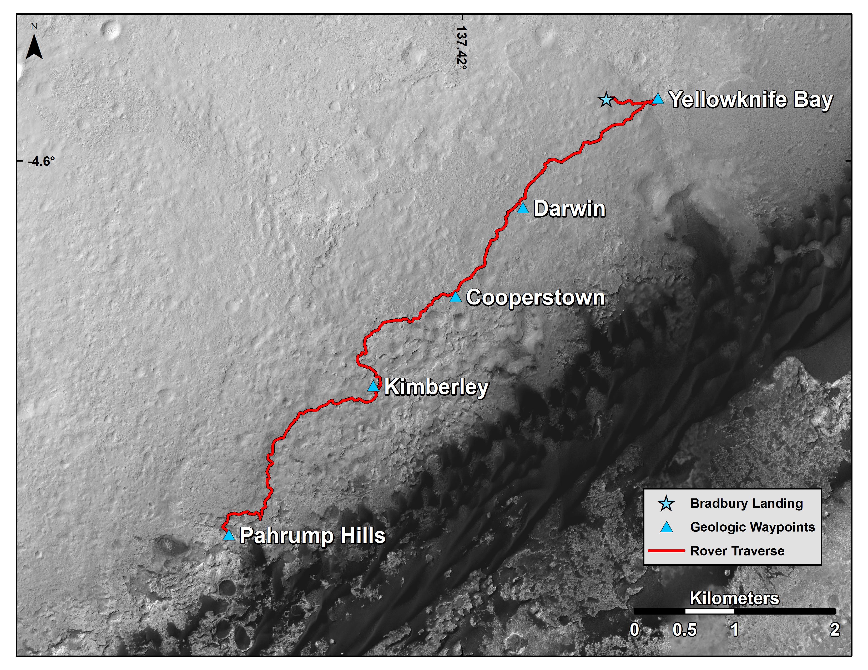
Curiosity's Route from Landing to 'Pahrump Hills' http://mars.jpl.nasa.gov/msl/multimedia/images/?ImageID=6855 Image Caption: Curiosity Mars Rover's Route from Landing to Base of Mount Sharp This map shows the route driven by NASA's Curiosity Mars rover from the location where it landed in August 2012 to the "Pahrump Hills" outcrop, which is part of the basal layer of Mount Sharp. The traverse line covers drives completed through the 817th Martian day, or sol, of Curiosity's work on Mars (Nov. 23, 2014). The base image for this map is from the High Resolution Imaging Science Experiment (HiRISE) camera on NASA's Mars Reconnaissance Orbiter. North is up. The dark ground south of the rover's route has dunes of dark, wind-blown material at the foot of Mount Sharp. The scale bar at lower right represents two kilometers (1.2 miles). For broader-context images of the area, see http://photojournal.jpl.nasa.gov/catalog/PIA17355, http://photojournal.jpl.nasa.gov/catalog/PIA16064 and http://photojournal.jpl.nasa.gov/catalog/PIA16058. NASA's Jet Propulsion Laboratory, a division of the California Institute of Technology, Pasadena, manages the Mars Science Laboratory Project and Mars Reconnaissance Orbiter Project for NASA's Science Mission Directorate, Washington. For more information about the Mars Science Laboratory mission and the mission's Curiosity rover, visit http://www.nasa.gov/msl and http://mars.nasa.gov/msl. |
| Tarih | |
| Kaynak | http://mars.jpl.nasa.gov/msl/images/Mars-Curiosity-Rover-Traverse-Map-Gupta-Waypoints-sol0817-pia19067-full.jpg |
| Yazar | NASA/JPL-Caltech/Univ. of Arizona |
Lisanslama

|
Bu dosyanın telif hakkı sahibi, NASA/JPL-Caltech, telif hakkına uygun şekilde atıfta bulunmak koşuluyla herkese herhangi bir amaç için bu çalışmayı kullanmak üzere izin vermiştir. |
|
|
| According to JPL's image use policy additional restriction is that no endorsement of any product or service by Caltech, JPL or NASA is claimed or implied.
Caltech's disclaimer: Caltech makes no representations or warranties with respect to ownership of copyrights in the images, and does not represent others who may claim to be authors or owners of copyright of any of the images, and makes no warranties as to the quality of the images. Caltech shall not be responsible for any loss or expenses resulting from the use of the images, and you release and hold Caltech harmless from all liability arising from such use. Usage on the English Wikipedia: On the English Wikipedia you can use the {{JPL Image}} template to display the copyright notice. (See w:Wikipedia:Using JPL images for details) |
Dosya geçmişi
Dosyanın herhangi bir zamandaki hâli için ilgili tarih/saat kısmına tıklayın.
| Tarih/Saat | Küçük resim | Boyutlar | Kullanıcı | Yorum | |
|---|---|---|---|---|---|
| güncel | 20.57, 8 Aralık 2014 | | 3.300 × 2.550 (1,22 MB) | Drbogdan | User created page with UploadWizard |
Dosya kullanımı
Bu görüntü dosyasına bağlantısı olan sayfalar:
Küresel dosya kullanımı
Aşağıdaki diğer vikiler bu dosyayı kullanmaktadır:
- fr.wikipedia.org üzerinde kullanımı