
Dosya:PIA17596-MarsCuriosityRover-AncientLake-20131209.jpg

Bu dosya Wikimedia Commons'ta bulunmaktadır. Dosyanın açıklaması aşağıda gösterilmiştir. Commons, serbest/özgür telifli medya dosyalarının bulundurulduğu depodur. Siz de yardım edebilirsiniz. |
Özet
| Açıklama |
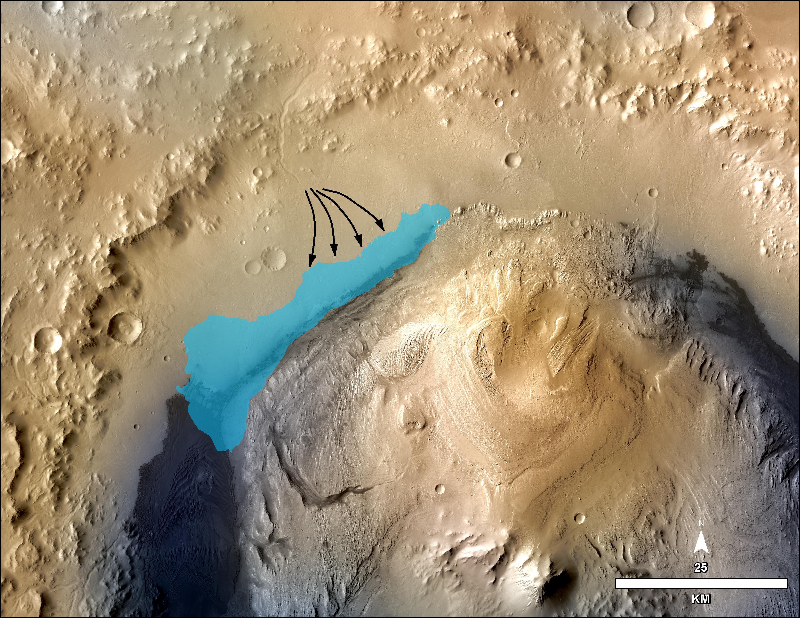
English: PIA17596: Possible Extent of Ancient Lake in Gale Crater, Mars
http://photojournal.jpl.nasa.gov/catalog/PIA17596 This illustration depicts a concept for the possible extent of an ancient lake inside Gale Crater. The existence of a lake there billions of years ago was confirmed from examination of mudstone in the crater's Yellowknife Bay area. For this illustration, the possible extent was estimated by mapping ancient lake and stream deposits and recognizing that water flowed from the crater rim into the basin (arrows). The water would have pooled in the linear depression created between the crater rim and Mt. Sharp. The area's history likely included the coming and going of multiple lakes of different sizes as climate conditions evolved. The base map combines image data from the Context Camera on NASA's Mars Reconnaissance Orbiter and color information from Viking Orbiter imagery. The 25-kilometer scale bar at lower right is 15.5 miles long. North is up. NASA's Jet Propulsion Laboratory, Pasadena, Calif., manages the Mars Science Laboratory Project and the mission's Curiosity rover for NASA's Science Mission Directorate in Washington. The rover was designed and assembled at JPL, a division of the California Institute of Technology in Pasadena. More information about Curiosity is online at http://www.nasa.gov/msl and http://mars.jpl.nasa.gov/msl/. |
| Tarih | |
| Kaynak | http://photojournal.jpl.nasa.gov/jpeg/PIA17596.jpg |
| Yazar | NASA/JPL-Caltech/MSSS |
Lisanslama

|
Bu dosyanın telif hakkı sahibi, NASA/JPL-Caltech, telif hakkına uygun şekilde atıfta bulunmak koşuluyla herkese herhangi bir amaç için bu çalışmayı kullanmak üzere izin vermiştir. |
|
|
| According to JPL's image use policy additional restriction is that no endorsement of any product or service by Caltech, JPL or NASA is claimed or implied.
Caltech's disclaimer: Caltech makes no representations or warranties with respect to ownership of copyrights in the images, and does not represent others who may claim to be authors or owners of copyright of any of the images, and makes no warranties as to the quality of the images. Caltech shall not be responsible for any loss or expenses resulting from the use of the images, and you release and hold Caltech harmless from all liability arising from such use. Usage on the English Wikipedia: On the English Wikipedia you can use the {{JPL Image}} template to display the copyright notice. (See w:Wikipedia:Using JPL images for details) |
Dosya geçmişi
Dosyanın herhangi bir zamandaki hâli için ilgili tarih/saat kısmına tıklayın.
| Tarih/Saat | Küçük resim | Boyutlar | Kullanıcı | Yorum | |
|---|---|---|---|---|---|
| güncel | 15.48, 14 Aralık 2013 | | 3.300 × 2.550 (1,28 MB) | Drbogdan | User created page with UploadWizard |
Dosya kullanımı
Bu görüntü dosyasına bağlantısı olan sayfalar:
Küresel dosya kullanımı
Aşağıdaki diğer vikiler bu dosyayı kullanmaktadır:
- en.wikipedia.org üzerinde kullanımı
- es.wikipedia.org üzerinde kullanımı
- it.wikipedia.org üzerinde kullanımı
- ja.wikipedia.org üzerinde kullanımı
- pnb.wikipedia.org üzerinde kullanımı
- uk.wikipedia.org üzerinde kullanımı
- ur.wikipedia.org üzerinde kullanımı
- zh.wikipedia.org üzerinde kullanımı