
Dosya:PIA17587-MarsCuriosityRover-MurrayButtes-20131113.jpg

Bu dosya Wikimedia Commons'ta bulunmaktadır. Dosyanın açıklaması aşağıda gösterilmiştir. Commons, serbest/özgür telifli medya dosyalarının bulundurulduğu depodur. Siz de yardım edebilirsiniz. |
Özet
| Açıklama |
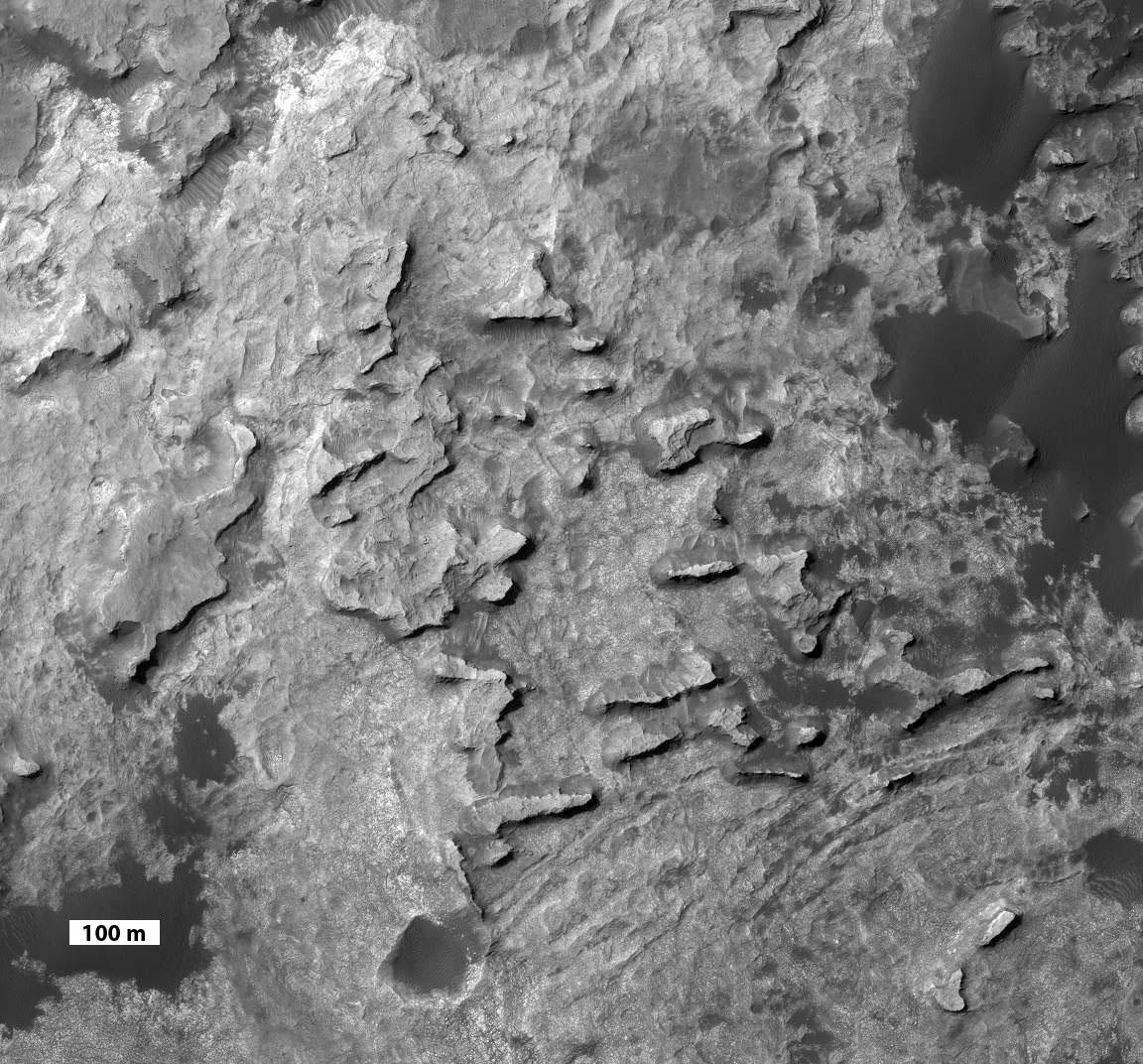
English: PIA17587: 'Murray Buttes' at Foot of Mount Sharp on Mars
http://photojournal.jpl.nasa.gov/catalog/PIA17587 This view taken from orbit shows a cluster of small, steep-sided knobs called "Murray Buttes," on the planned route for NASA's Mars rover Curiosity to reach the slopes of Mount Sharp. The scene covers a patch of ground about 0.8 mile (1.3 kilometers) across. North is up. The largest buttes in the group are about the size of a football field and the height of a goal post. Darker ground at upper right and lower left is part of sand dunes along the northern edge of Mount Sharp, within Gale Crater. Murray Buttes is located at a gap in that band of dunes, making passage through this area an attractive access route to the mountain slopes just south of this scene. Curiosity's science team chose the informal name Murray Buttes in tribute to Bruce Murray (1931-2013), an influential advocate for planetary exploration who was a member of the science teams for NASA's earliest missions to Mars and later served as director of NASA's Jet Propulsion Laboratory. The image is a portion of an observation made by the High Resolution Imaging Science Experiment (HiRISE) camera aboard NASA's Mars Reconnaissance Orbiter. A scale bar of 100 meters (328 feet) is provided at lower left. |
| Tarih | |
| Kaynak | http://photojournal.jpl.nasa.gov/jpeg/PIA17587.jpg |
| Yazar | NASA/JPL-Caltech |
Lisanslama

|
Bu dosyanın telif hakkı sahibi, NASA/JPL-Caltech, telif hakkına uygun şekilde atıfta bulunmak koşuluyla herkese herhangi bir amaç için bu çalışmayı kullanmak üzere izin vermiştir. |
|
|
| According to JPL's image use policy additional restriction is that no endorsement of any product or service by Caltech, JPL or NASA is claimed or implied.
Caltech's disclaimer: Caltech makes no representations or warranties with respect to ownership of copyrights in the images, and does not represent others who may claim to be authors or owners of copyright of any of the images, and makes no warranties as to the quality of the images. Caltech shall not be responsible for any loss or expenses resulting from the use of the images, and you release and hold Caltech harmless from all liability arising from such use. Usage on the English Wikipedia: On the English Wikipedia you can use the {{JPL Image}} template to display the copyright notice. (See w:Wikipedia:Using JPL images for details) |
Dosya geçmişi
Dosyanın herhangi bir zamandaki hâli için ilgili tarih/saat kısmına tıklayın.
| Tarih/Saat | Küçük resim | Boyutlar | Kullanıcı | Yorum | |
|---|---|---|---|---|---|
| güncel | 14.51, 14 Kasım 2013 | | 1.152 × 1.072 (242 KB) | Drbogdan | User created page with UploadWizard |
Dosya kullanımı
Bu görüntü dosyasına bağlantısı olan sayfalar:
Küresel dosya kullanımı
Aşağıdaki diğer vikiler bu dosyayı kullanmaktadır:
- ar.wikipedia.org üzerinde kullanımı
- en.wikipedia.org üzerinde kullanımı
- fa.wikipedia.org üzerinde kullanımı
- fr.wikipedia.org üzerinde kullanımı
- it.wikipedia.org üzerinde kullanımı
- sr.wikipedia.org üzerinde kullanımı
- uk.wikipedia.org üzerinde kullanımı
- zh.wikipedia.org üzerinde kullanımı