
Dosya:PIA17085-MarsCuriosityRover-TraverseMap-Sol351-20130801.jpg

Bu dosya Wikimedia Commons'ta bulunmaktadır. Dosyanın açıklaması aşağıda gösterilmiştir. Commons, serbest/özgür telifli medya dosyalarının bulundurulduğu depodur. Siz de yardım edebilirsiniz. |
Özet
| Açıklama |
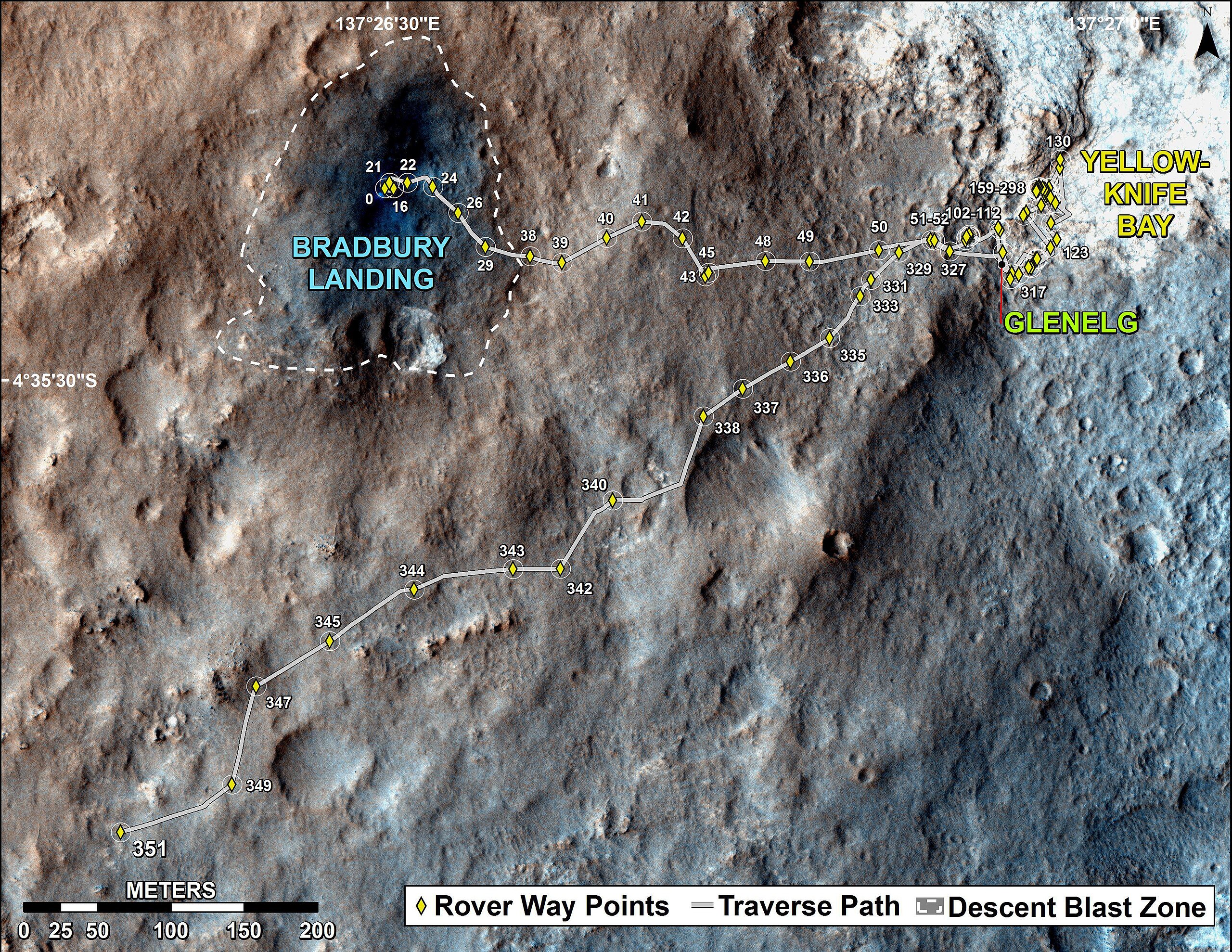
English: PIA17085: Full Curiosity Traverse Passes One-Mile Mark
http://photojournal.jpl.nasa.gov/catalog/PIA17085 NOTE: UPDATED Traverse Maps Are Here => http://mars.jpl.nasa.gov/msl/mission/whereistherovernow/ NOTE: First-Year & First-Mile Traverse Map of the Curiosity rover on Mars (August 1, 2013) (3-D). NASA Description: The total distance driven by NASA's Mars rover Curiosity passed the one-mile mark a few days before the first anniversary of the rover's landing on Mars. This map traces where Curiosity drove between landing at "Bradbury Landing" on Aug. 5, 2012, PDT, (Aug. 6, 2012 (Universal Time and EDT) and the position reached during the mission's 351st Martian day, or sol, (Aug. 1, 2013). The Sol 351 leg added 279 feet (85.1 meters) and brought the odometry since landing to about 1.05 miles (1,686 meters). The mapped area is within Gale Crater and north of the mountain called Mount Sharp in the middle of the crater. After the first use of the drill, the rover's main science destination will be on the lower reaches of Mount Sharp. For broader-context images of the area, see PIA16064 and PIA16058. The base image from the map is from the High Resolution Imaging Science Experiment Camera (HiRISE) in NASA's Mars Reconnaissance Orbiter. |
| Tarih | |
| Kaynak | http://photojournal.jpl.nasa.gov/jpeg/PIA17085.jpg |
| Yazar | NASA/JPL-Caltech/Univ. of Arizona |
Lisanslama

|
Bu dosyanın telif hakkı sahibi, NASA/JPL-Caltech, telif hakkına uygun şekilde atıfta bulunmak koşuluyla herkese herhangi bir amaç için bu çalışmayı kullanmak üzere izin vermiştir. |
|
|
| According to JPL's image use policy additional restriction is that no endorsement of any product or service by Caltech, JPL or NASA is claimed or implied.
Caltech's disclaimer: Caltech makes no representations or warranties with respect to ownership of copyrights in the images, and does not represent others who may claim to be authors or owners of copyright of any of the images, and makes no warranties as to the quality of the images. Caltech shall not be responsible for any loss or expenses resulting from the use of the images, and you release and hold Caltech harmless from all liability arising from such use. Usage on the English Wikipedia: On the English Wikipedia you can use the {{JPL Image}} template to display the copyright notice. (See w:Wikipedia:Using JPL images for details) |
Dosya geçmişi
Dosyanın herhangi bir zamandaki hâli için ilgili tarih/saat kısmına tıklayın.
| Tarih/Saat | Küçük resim | Boyutlar | Kullanıcı | Yorum | |
|---|---|---|---|---|---|
| güncel | 22.17, 2 Ağustos 2013 | | 3.300 × 2.550 (2,15 MB) | Drbogdan | User created page with UploadWizard |
Dosya kullanımı
Bu görüntü dosyasına bağlantısı olan sayfalar:
Küresel dosya kullanımı
Aşağıdaki diğer vikiler bu dosyayı kullanmaktadır:
- ca.wikipedia.org üzerinde kullanımı
- en.wikipedia.org üzerinde kullanımı
- es.wikipedia.org üzerinde kullanımı
- fa.wikipedia.org üzerinde kullanımı
- fr.wikipedia.org üzerinde kullanımı
- it.wikipedia.org üzerinde kullanımı
- ja.wikipedia.org üzerinde kullanımı
- ko.wikipedia.org üzerinde kullanımı
- pl.wikipedia.org üzerinde kullanımı
- ru.wikipedia.org üzerinde kullanımı
- uk.wikipedia.org üzerinde kullanımı
- vi.wikipedia.org üzerinde kullanımı
- zh.wikipedia.org üzerinde kullanımı