
Dosya:MarsCuriosityRover-TraverseMap-Sol-0746-20140911.jpg

Bu dosya Wikimedia Commons'ta bulunmaktadır. Dosyanın açıklaması aşağıda gösterilmiştir. Commons, serbest/özgür telifli medya dosyalarının bulundurulduğu depodur. Siz de yardım edebilirsiniz. |
Özet
| Açıklama |
English: 09.11.2014
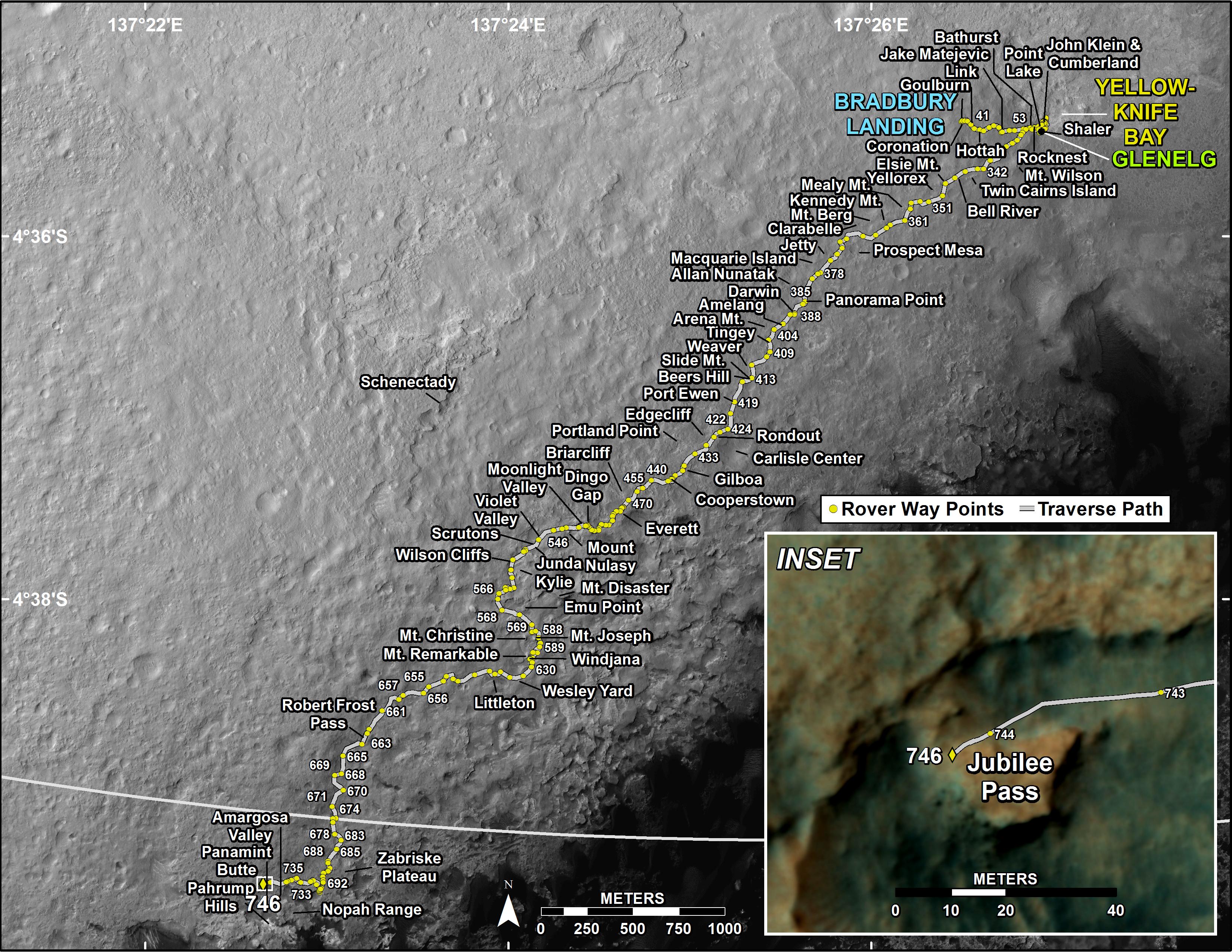
Curiosity's Traverse Map Through Sol 746 - Arrival at the slopes of Mount Sharp in Gale Crater on the planet Mars. http://mars.jpl.nasa.gov/msl/multimedia/images/?ImageID=6587 This map shows the route driven by NASA's Mars rover Curiosity through the 746 Martian day, or sol, of the rover's mission on Mars (September 11, 2014). Numbering of the dots along the line indicate the sol number of each drive. North is up. The scale bar is 1 kilometer (~0.62 mile). From Sol 744 to Sol 746, Curiosity had driven a straight line distance of about 26.19 feet (7.983 meters). The base image from the map is from the High Resolution Imaging Science Experiment Camera (HiRISE) in NASA's Mars Reconnaissance Orbiter. |
| Tarih | |
| Kaynak | http://mars.jpl.nasa.gov/msl/images/MSL_TraverseMap_Sol0746-full.jpg |
| Yazar | NASA/JPL-Caltech/Univ. of Arizona |
Lisanslama

|
Bu dosyanın telif hakkı sahibi, NASA/JPL-Caltech, telif hakkına uygun şekilde atıfta bulunmak koşuluyla herkese herhangi bir amaç için bu çalışmayı kullanmak üzere izin vermiştir. |
|
|
| According to JPL's image use policy additional restriction is that no endorsement of any product or service by Caltech, JPL or NASA is claimed or implied.
Caltech's disclaimer: Caltech makes no representations or warranties with respect to ownership of copyrights in the images, and does not represent others who may claim to be authors or owners of copyright of any of the images, and makes no warranties as to the quality of the images. Caltech shall not be responsible for any loss or expenses resulting from the use of the images, and you release and hold Caltech harmless from all liability arising from such use. Usage on the English Wikipedia: On the English Wikipedia you can use the {{JPL Image}} template to display the copyright notice. (See w:Wikipedia:Using JPL images for details) |
Dosya geçmişi
Dosyanın herhangi bir zamandaki hâli için ilgili tarih/saat kısmına tıklayın.
| Tarih/Saat | Küçük resim | Boyutlar | Kullanıcı | Yorum | |
|---|---|---|---|---|---|
| güncel | 20.01, 19 Eylül 2014 | | 3.300 × 2.550 (1,34 MB) | Drbogdan | User created page with UploadWizard |
Dosya kullanımı
Bu görüntü dosyasına bağlantısı olan sayfalar:
Küresel dosya kullanımı
Aşağıdaki diğer vikiler bu dosyayı kullanmaktadır:
- en.wikipedia.org üzerinde kullanımı
- uk.wikipedia.org üzerinde kullanımı
- zh.wikipedia.org üzerinde kullanımı