Dosya:Khanate of Baku in the Map of Caucasus with the borders.jpg - Vikipedi
İçeriğe atla
Ana menü
Gezinti
  • Anasayfa
  • Hakkımızda
  • İçindekiler
  • Rastgele madde
  • Seçkin içerik
  • Yakınımdakiler
Katılım
  • Deneme tahtası
  • Köy çeşmesi
  • Son değişiklikler
  • Dosya yükle
  • Topluluk portalı
  • Wikimedia dükkânı
  • Yardım
  • Özel sayfalar
Vikipedi Özgür Ansiklopedi
Ara
  • Bağış yapın
  • Hesap oluştur
  • Oturum aç
  • Bağış yapın
  • Hesap oluştur
  • Oturum aç

Dosya:Khanate of Baku in the Map of Caucasus with the borders.jpg

Sayfa içeriği diğer dillerde desteklenmemektedir.
  • Dosya
  • Tartışma
  • Oku
  • Wikimedia Commons üzerinde gör
  • Yerel açıklama ekle
  • Yerel açıklama kaynağı ekle
Araçlar
Eylemler
  • Oku
  • Wikimedia Commons üzerinde gör
  • Yerel açıklama ekle
  • Yerel açıklama kaynağı ekle
Genel
  • Sayfaya bağlantılar
  • Basılmaya uygun görünüm
  • Sayfa bilgisi
  • Kısaltılmış URL'yi al
  • Karekodu indir
Diğer projelerde
Görünüm
Vikipedi, özgür ansiklopedi
  • Dosya
  • Dosya geçmişi
  • Dosya kullanımı
  • Küresel dosya kullanımı
  • Üstveri
Dosya:Khanate of Baku in the Map of Caucasus with the borders.jpg
Bu önizlemenin boyutu: 471 × 600 piksel. Diğer çözünürlükler: 188 × 240 piksel | 377 × 480 piksel | 603 × 768 piksel | 804 × 1.024 piksel | 1.609 × 2.048 piksel | 3.000 × 3.819 piksel.
Tam çözünürlük ((3.000 × 3.819 piksel, dosya boyutu: 3,26 MB, MIME tipi: image/jpeg))
Bu dosya Wikimedia Commons'ta bulunmaktadır. Dosyanın açıklaması aşağıda gösterilmiştir.
Commons, serbest/özgür telifli medya dosyalarının bulundurulduğu depodur. Siz de yardım edebilirsiniz.
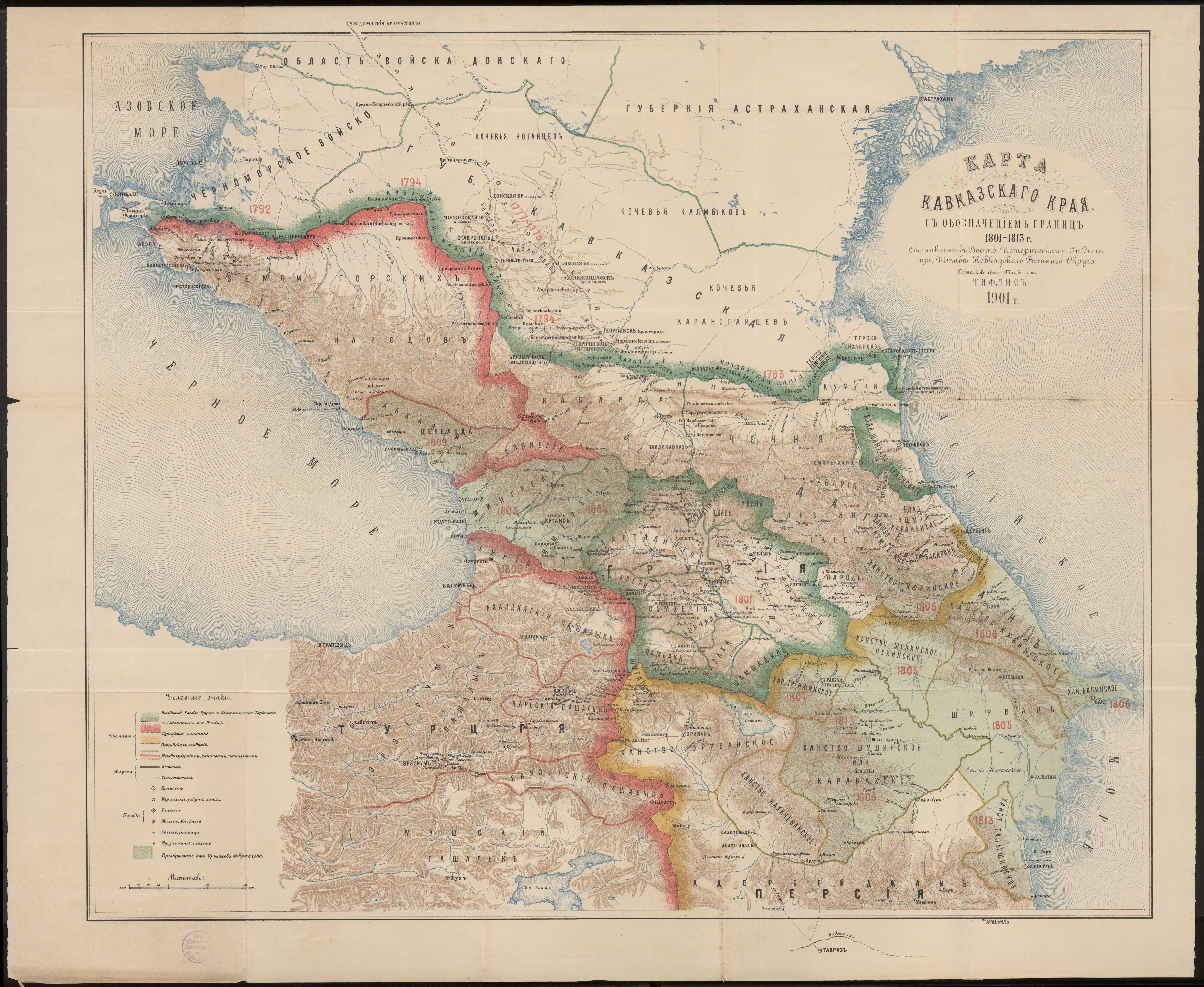
Bu dosya Wikimedia Commons'ta bulunmaktadır.

AçıklamaKhanate of Baku in the Map of Caucasus with the borders.jpg
English: Khanate of Baku in the Map of Caucasus with the borders.
Tarih 1901
Kaynak Карта Кавказского края с обозначением границ 1801-1813 г. Составлена в военно-историческом отделе при штабе Кавказского военного округа подполковником Томкиевым. Тифлис 1901 г.
Yazar Владимир Ильич Томкеев
Public domainPublic domainfalsefalse
Public domain
This work was published on territory of the Russian Empire (Russian Republic) except for territories of the Grand Duchy of Finland and Congress Poland before 7 November 1917 and wasn't re-published for 30 days following initial publications on the territory of Soviet Russia or any other countries.

The Russian Federation (early Soviet Russia, RSFSR) is the historical heir but not legal successor of the Russian Empire, and the Russian Empire was not party to the Berne Convention (it was not country of Union for the protection of the rights of authors in their literary and artistic works), so according to article 5 of the Convention this work has no country of origin except:

  • in the case of cinematographic work the maker of which has his headquarters or his habitual residence in a country of the Union, the country of origin shall be that country,
  • in the case of architecture erected in a country of the Union or other artistic works incorporated in a building or other structure located in a country of the Union, the country of origin shall be that country,
  • in the case of other works if the author is a national of a country of the Union¹, the country of origin shall be that country.

¹ - Author who is not a national of a country of the Union but who has his habitual residence in a country of the Union, be assimilated to national of that country.


If applicable, {{PD-Russia-expired}} should be used instead of this tag.


Bu çalışma 1 Ocak 1930 tarihinden önce yayımlanmıştır (veya ABD Telif Hakkı Ofisinde kayıtlıdır). Bu nedenle eser ABD'de kamu malıdır.

Flag of Russia
Flag of Russia

Altyazılar

Bu dosyanın temsil ettiği şeyin tek satırlık açıklamasını ekleyin.
Khanate of Baku in the Map of Caucasus with the borders

Bu dosyada gösterilen öğeler

betimlenen

kuruluşu

1901

Dosya geçmişi

Dosyanın herhangi bir zamandaki hâli için ilgili tarih/saat kısmına tıklayın.

Tarih/SaatKüçük resimBoyutlarKullanıcıYorum
güncel20.14, 1 Mayıs 202020.14, 1 Mayıs 2020 tarihindeki sürümün küçültülmüş hâli3.000 × 3.819 (3,26 MB)Sword313Uploaded a work by Владимир Ильич Томкеев from [http://xn--b1aaibpv0aet4h1a.xn--p1ai/forums/uploads/gallery/album_19/gallery_4_19_4287845.jpg Карта Кавказского края с обозначением границ 1801-1813 г. Составлена в военно-историческом отделе при штабе Кавказского военного округа подполковником Томкиевым. Тифлис 1901 г.] with UploadWizard

Dosya kullanımı

Bu görüntü dosyasına bağlantısı olan sayfalar:

  • Bakü Hanlığı

Küresel dosya kullanımı

Aşağıdaki diğer vikiler bu dosyayı kullanmaktadır:

  • ca.wikipedia.org üzerinde kullanımı
    • Kanat de Bakú
  • fa.wikipedia.org üzerinde kullanımı
    • خانات باکو
  • fr.wikipedia.org üzerinde kullanımı
    • Khanat de Bakou
  • hy.wikipedia.org üzerinde kullanımı
    • Բաքվի խանություն
  • it.wikipedia.org üzerinde kullanımı
    • Khanato di Baku
  • nl.wikipedia.org üzerinde kullanımı
    • Kanaat Bakoe
  • pt.wikipedia.org üzerinde kullanımı
    • Canato de Bacu
  • ru.wikipedia.org üzerinde kullanımı
    • Бакинское ханство
  • uk.wikipedia.org üzerinde kullanımı
    • Бакинське ханство
  • www.wikidata.org üzerinde kullanımı
    • Q1740533

Üstveri

Bu dosyada, muhtemelen fotoğraf makinesi ya da tarayıcı tarafından eklenmiş ek bilgiler mevcuttur. Eğer dosyada sonradan değişiklik yapıldıysa, bazı bilgiler yeni değişikliğe göre eski kalmış olabilir.

YönlendirmeNormal
Yatay çözünürlük72 dpi
Dikey çözünürlük72 dpi
Kullanılan yazılımAdobe Photoshop CS Windows
Dosya değişiklik tarihi ve zamanı03.10, 2 Mayıs 2020
Renk aralığıKalibrasyonsuz
Resim genişliği3.000 px
Resim yüksekliği3.819 px
Dijitalleştirme zamanı10.10, 2 Mayıs 2020
Üst veri son değişim tarihi10.10, 2 Mayıs 2020
IIM sürümü2
"https://tr.wikipedia.org/wiki/Dosya:Khanate_of_Baku_in_the_Map_of_Caucasus_with_the_borders.jpg" sayfasından alınmıştır
  • Gizlilik politikası
  • Vikipedi hakkında
  • Sorumluluk reddi
  • Davranış Kuralları
  • Geliştiriciler
  • İstatistikler
  • Çerez politikası
  • Mobil görünüm
  • Wikimedia Foundation
  • Powered by MediaWiki
Dosya:Khanate of Baku in the Map of Caucasus with the borders.jpg
Konu ekle