
Dosya:DST Countries Map.png

Bu önizlemenin boyutu: 800 × 355 piksel. Diğer çözünürlükler: 320 × 142 piksel | 640 × 284 piksel | 1.024 × 454 piksel | 1.280 × 568 piksel | 2.560 × 1.136 piksel | 4.952 × 2.197 piksel.
Tam çözünürlük ((4.952 × 2.197 piksel, dosya boyutu: 487 KB, MIME tipi: image/png))
Bu dosya Wikimedia Commons'ta bulunmaktadır. Dosyanın açıklaması aşağıda gösterilmiştir. Commons, serbest/özgür telifli medya dosyalarının bulundurulduğu depodur. Siz de yardım edebilirsiniz. |
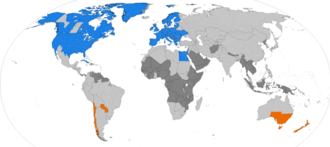
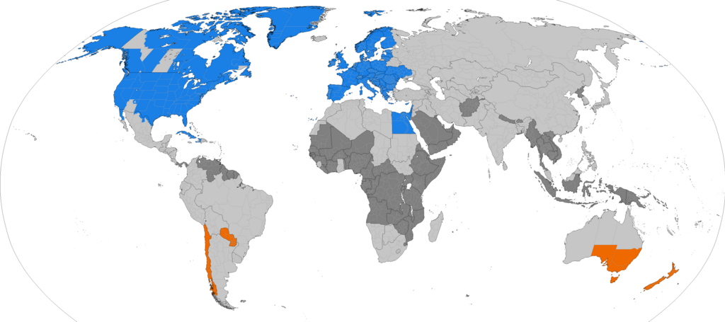
Dark grey places have never used daylight savings, light grey places formerly used it. Orange places use daylight savings in the southern hemisphere summer. Blue places use daylight savings in the northern hemisphere summer.
| Bu dosya yeni bilgileri yansıtacak şekilde güncellenebilir. Dosyanın belirli bir sürümünü üzerine yazılmadan kullanmak istiyorsanız, lütfen gerekli sürümü ayrı bir dosya olarak yükleyin. |

|
Bu galeride bulunan tüm resimler vektörel grafikler kullanılarak SVG dosyası şeklinde oluşturulmalıdır. Bunun çeşitli avantajları vardır; daha fazla bilgi için Commons:Temizleme medyası sayfasına bakın. Eğer bu resmin SVG formatına sahipseniz, lütfen yükleyin. Lütfen SVG dosyanızı yükledikten sonra, bu şablonu bu resimdeki {{vector version available|yeni resim ismi.svg}} şablonu ile değiştirin.
|
Özet
| Açıklama |
English: Larger map of the previous version. Distinguished from summertime in the northern hemisphere and southern hemisphere.
Northern hemisphere summer
Southern hemisphere summer
Formerly used daylight savings
Never used daylight savings Bahasa Indonesia: Peta yang lebih besar dari versi sebelumnya. Membedakan masa musim panas di belahan bumi utara dan selatan.
Musim panas belahan bumi utara
Musim panas belahan bumi utara
Menggunakan waktu musim panas di masa lampau
Tidak pernah menggunakan waktu musim panas |
| Tarih | |
| Kaynak | Yükleyenin kendi çalışması |
| Yazar | TimeZonesBoy |
| Diğer sürümler |
Supplementary map: |

Lisanslama
Ben, bu işin telif sahibi, burada işi aşağıdaki lisans altında yayımlıyorum:
Bu dosya, Creative Commons Atıf-Benzer Paylaşım 3.0 Taşınmamış lisansı ile lisanslanmıştır
- Şu seçeneklerde özgürsünüz:
- paylaşım – eser paylaşımı, dağıtımı ve iletimi
- içeriği değiştirip uyarlama – eser adaptasyonu
- Aşağıdaki koşullar geçerli olacaktır:
- atıf – Esere yazar veya lisans sahibi tarafından belirtilen (ancak sizi ya da eseri kullanımınızı desteklediklerini ileri sürmeyecek bir) şekilde atıfta bulunmalısınız.
- benzer paylaşım – Maddeyi yeniden düzenler, dönüştürür veya inşa ederseniz, katkılarınızı özgünüyle aynı veya uyumlu lisans altında dağıtmanız gerekir.
Dosya geçmişi
Dosyanın herhangi bir zamandaki hâli için ilgili tarih/saat kısmına tıklayın.
| Tarih/Saat | Küçük resim | Boyutlar | Kullanıcı | Yorum | |
|---|---|---|---|---|---|
| güncel | 15.09, 22 Aralık 2025 | | 4.952 × 2.197 (487 KB) | NormandMapping | Complied to leave all black borders intact; reintegrated previous subdivision fixes; fixed Bhutan (the north has been occupied by China since before it abolished its DST); added Mymensingh Division to Bangladesh; fixed more miscoloured pixels in Turkey and Tunisia. |
| 19.16, 20 Aralık 2025 |  | 4.952 × 2.197 (451 KB) | M.Bitton | Reverted to version as of 00:52, 4 December 2025 (UTC): per WP:COMOVERWRITE you shoudn't fiddle with the borders (tou removed the one bwteen Morocco and Western Sahara) | |
| 10.50, 20 Aralık 2025 |  | 4.952 × 2.197 (487 KB) | NormandMapping | Fixed miscoloured pixels in the Gambia, Guinea-Bissau, Nigeria, Indonesia. Updated Indonesian subdivisions (split Papua). Fixed French Guiana to be region-level like the rest of France. Marked more disputed borders (South America, Korean DMZ [the solution used in CIA World Factbook maps], Kosovo [consistent with other limited-recognition states; keeping the UNMIK districts], Western Sahara [reflecting UN Resolution 2797, de facto supporting the Morocco autonomy plan]). | |
| 19.37, 17 Aralık 2025 |  | 4.952 × 2.197 (487 KB) | NormandMapping | Subdivision fixes• Added Lubusz to Poland. • Added Kyiv City to Ukraine. • Added a proper border between Viciebsk and Hrodna in Belarus. • Added a proper border between Borsod–Abaúj–Zemplén and Nógrád in Northern Hungary. • Fixed the Emilia-Romagna southern border in Italy. • Adjusted Shida Kartli de jure borders in Georgia. • Adjusted Prizren district borders in Kosovo. • Merged a nonexistent Egyptian governorate into Red Sea Governorate. Territorial disputes • Cleaned up and updated de fac... | |
| 00.52, 4 Aralık 2025 |  | 4.952 × 2.197 (451 KB) | Tcfc2349 | fixed | |
| 22.41, 14 Kasım 2025 |  | 4.952 × 2.197 (710 KB) | American Angel1 | Fixed Borders of Donetsk Oblast and Put Lands in Donetsk and Zaporizhzhia Oblasts as no longer Using Daylight Savings Time(DST) | |
| 00.34, 24 Mart 2025 |  | 4.952 × 2.197 (462 KB) | Heitordp | Updated Chile | |
| 00.30, 15 Ekim 2024 |  | 4.952 × 2.197 (462 KB) | Heitordp | Updated Paraguay | |
| 06.06, 31 Mart 2024 |  | 4.952 × 2.197 (462 KB) | Heitordp | Adjusted Greenland | |
| 11.27, 31 Aralık 2023 |  | 4.952 × 2.197 (462 KB) | Heitordp | Updated Greenland, disputed borders, subdivisions of France, Morocco, DR Congo, South Sudan, Ethiopia, Somalia, India |
Dosya kullanımı
Bu görüntü dosyasına bağlantısı olan sayfalar:
Küresel dosya kullanımı
Aşağıdaki diğer vikiler bu dosyayı kullanmaktadır:
- ar.wikipedia.org üzerinde kullanımı
- azb.wikipedia.org üzerinde kullanımı
- bs.wikipedia.org üzerinde kullanımı
- ckb.wikipedia.org üzerinde kullanımı
- en.wikipedia.org üzerinde kullanımı
- es.wikipedia.org üzerinde kullanımı
- fa.wikipedia.org üzerinde kullanımı
- ga.wikipedia.org üzerinde kullanımı
- hu.wikipedia.org üzerinde kullanımı
- hy.wikipedia.org üzerinde kullanımı
- ja.wikipedia.org üzerinde kullanımı
- la.wikipedia.org üzerinde kullanımı
- lo.wikipedia.org üzerinde kullanımı
- lt.wikipedia.org üzerinde kullanımı
- ne.wikipedia.org üzerinde kullanımı
- pnb.wikipedia.org üzerinde kullanımı
- ru.wikipedia.org üzerinde kullanımı
- sh.wikipedia.org üzerinde kullanımı
- simple.wikipedia.org üzerinde kullanımı
- sq.wikipedia.org üzerinde kullanımı
- sr.wikipedia.org üzerinde kullanımı
- ta.wikipedia.org üzerinde kullanımı
- th.wikipedia.org üzerinde kullanımı
- vi.wikipedia.org üzerinde kullanımı
- zh.wikipedia.org üzerinde kullanımı