
Dosya:Balkan peninsula line.jpg
Daha yüksek çözünürlüğe sahip sürüm bulunmamaktadır.
Balkan_peninsula_line.jpg ((558 × 530 piksel, dosya boyutu: 169 KB, MIME tipi: image/jpeg))
Bu dosya Wikimedia Commons'ta bulunmaktadır. Dosyanın açıklaması aşağıda gösterilmiştir. Commons, serbest/özgür telifli medya dosyalarının bulundurulduğu depodur. Siz de yardım edebilirsiniz. |
Özet
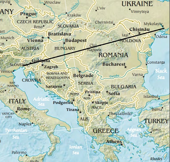
| Açıklama | Map of the Balkan peninsula, showing the line stretching from the northernmost point of the Adriatic to the northernmost point of the Black Sea. Made from Europe map at The Central Intelligence Agency World Factbook, which is in the public domain. |
| Kaynak | https://www.cia.gov/library/publications/the-world-factbook//graphics/ref_maps/physical/jpg/europe.jpg |
| Yazar | CIA |
| Diğer sürümler |
|
.jpg)
Lisanslama
ABD Merkezi İstihbarat Teşkilatı'nın World Factbook'tan gelen malzemeler içerdiğinden bu görüntü kamu malıdır.
|
 |

|
Bu galeride bulunan tüm resimler vektörel grafikler kullanılarak SVG dosyası şeklinde oluşturulmalıdır. Bunun çeşitli avantajları vardır; daha fazla bilgi için Commons:Temizleme medyası sayfasına bakın. Eğer bu resmin SVG formatına sahipseniz, lütfen yükleyin. Lütfen SVG dosyanızı yükledikten sonra, bu şablonu bu resimdeki {{vector version available|yeni resim ismi.svg}} şablonu ile değiştirin.
|


Dosya geçmişi
Dosyanın herhangi bir zamandaki hâli için ilgili tarih/saat kısmına tıklayın.
| Tarih/Saat | Küçük resim | Boyutlar | Kullanıcı | Yorum | |
|---|---|---|---|---|---|
| güncel | 12.27, 16 Ocak 2014 | | 558 × 530 (169 KB) | Denniss | Reverted to version as of 22:51, 26 December 2013 |
| 21.21, 15 Ocak 2014 |  | 348 × 382 (43 KB) | Ivan VA | stop vandalizing maps | |
| 22.51, 26 Aralık 2013 |  | 558 × 530 (169 KB) | No More Cats | Please don't revert to outdated versions of maps | |
| 22.43, 26 Aralık 2013 |  | 348 × 382 (43 KB) | Nikola Smolenski | Reverted to version as of 19:13, 3 November 2006 | |
| 16.06, 17 Aralık 2013 |  | 558 × 530 (169 KB) | No More Cats | Map of the Balkan peninsula, showing the line stretching from the northernmost point of the Adriatic to the northernmost point of the Black Sea. Made from most recent map at [https://www.cia.gov/cia/publications/factbook/reference_maps/jpg/europe.jpg]. | |
| 19.13, 3 Kasım 2006 |  | 348 × 382 (43 KB) | Nikola Smolenski | Map of the Balkan peninsula, showing the line stretching from the northernmost point of the Adriatic to the northernmost point of the Black Sea. Made from map at [https://www.cia.gov/cia/publications/factbook/reference_maps/jpg/europe.jpg]. |
Dosya kullanımı
Bu görüntü dosyasına bağlantısı olan sayfalar:
Küresel dosya kullanımı
Aşağıdaki diğer vikiler bu dosyayı kullanmaktadır:
- ar.wikipedia.org üzerinde kullanımı
- bs.wikipedia.org üzerinde kullanımı
- cs.wikipedia.org üzerinde kullanımı
- es.wikipedia.org üzerinde kullanımı
- hu.wikipedia.org üzerinde kullanımı
- hu.wiktionary.org üzerinde kullanımı
- mk.wikipedia.org üzerinde kullanımı
- ro.wikipedia.org üzerinde kullanımı
- ru.wikipedia.org üzerinde kullanımı
- sk.wikipedia.org üzerinde kullanımı
- sl.wikipedia.org üzerinde kullanımı
- uk.wikipedia.org üzerinde kullanımı